![]()
Geological structure and surface , Climate , Waters , Folra , Fauna , Nature protection
Geological structure and surface
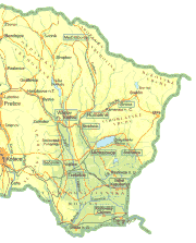
In the north part of Zemplín you may find these geomorphological units:Ondavská highlands, Laborecká highlands, Bukovské hills and Beskydské cape, which belong to the Outer East Carpathian.
The geological structure forms especially flysch palaentological and chalk layers of sandstone, clay, marly and conglomerate. The relief has got typical features of flysch mountains. In the middle part of Zemplin are Vihorlatské hills which belong geomorfologically to the Inner East Carpathian. They are divided into: Humenné hills with Krivoštianka and Sokol, Vihorlat with Kyjovská lowland, Vihorlat highland and Jasenská highland and Popriečny. Humenné hills, situated in klippen area, are built by secondary limestone, dolomite and marly. The mountain Vihorlat and Popriečny has got a volcanic origin, here appear cainozoic andesites of different kinds, their tuffs and pyroclastics. River flats are covered by river mud and the ground of Vihorlat hills by loess. The south part of Zemplín is covered by East-Slovak lowland, Zemplínske hills and from south-west by Slanské hills. East-Slovak lowland, an extensive area (4000 Km2), is a part of Big Danube fold. lt is divided into two regions: East-Slovak upland and in the south East-Slovak plane. East-Slovak lowland is repleted by neogene clays, sand, limestones and gravel. These rocks figure on the border of Slanské and Zemplínske hills. Along the rivers they are covered by river sediments, loesses, loess clay and in the south-east by drift sands. In East-Slovak upland are the deposits of mineral raw mainly brown coal and lignite (Hnojné, Sejkov) n ceramical raws are near Michalovce (halloyzite) and near Pozdvišovce (clay), bentonite near Nižný Žipov zeolite in Nižný Hrabovec - Kučín, salt is except Zbudza also in the of zone Rudlov Dlhé Klčovo. There is also a reach stock of building raws. The most valueable raw store is natural gas in the EastSlovak plane (Stretava, BánovceLastomir Pozdišovce-Trhovište, Trebišov, Senné, Albínov), gravelly sand on river flats of Laborec and Ondava and the deposits of stone salt. The sediment discharge of salt deposit in Zbudza ranges from 5 m to 300 m, the depht of deposit from 160 m to 600 m. The volume of salt deposit is around 1 mld. ton. The salt content is 86 %. In Medzibodrožie occur big sand dunes which are 25 m high, 1,5 km long and 150 m wide on the area of 170 Km2. Daily they are used for building activities.
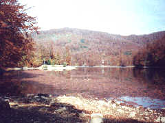
In the south part of East-Slovak lowland features a small mountain - Zemplinske hills. They are built by Palaeozoic and Secondary rocksn e.g. gneiss, sandstone, schist and young volcanic rocks. Zemplinske hills are interesting for its raw deposits. In Veľká Tŕňa and its surrondings are great deposits of black coal. A meaningful raw is also pearlite which deposits are in Malá Tŕňa, Veľká Bara, Viničky and other places. From south-west also appear Slanské hills which geomorphologically belong to Inner West Carpathian. They have come into existence by volcanic activity in cainozoic. On the bottom of the mountain toward EastSlovak lowland occur quartenary sediments. Mineral springs are near Sobrance, Michaľany and Veľaty. The area of East-Slovak plane with its thermal water is very perspective. Climatically is the region divided according to the height above sea-level into three zones. East-Slovak lowland, Beskydské mountain and Zemplínske hills belong to the warm climate zone which reaches along river valleys also Laborecká and Ondavská upland. This climate zone is the largest. Higher areas (til 800 m) as Slanské hills and a part of Virholat, Ondavská and Laborecká upland belong to temperate zone. Locations above 800 m belong to the cold climate zone. lt stretches along Polish border and goes to the apex parts of Vihorlaty The snow last from 80 to 100 days. Zemplín is after Podunajská lowland the second warmest zone in Slovakia. Average annual temperature ranges from 9 to 10°C. Especially a holiday resort Zemplínska širava and its surroundings have got excellent climate conditions. The average annual sunshine is 2200 hours.Average Zemplin temperature in lowland is from -1°C to -4°C, in higher location from -5°C to -7°C in January average temperature in July ranges from 18.5 to 20.5°C in lowland, higher from 12 to 16°C. Total rainfall is around 530 to 700 mm in lowland and 700 to 1000 mm in upland. Rainfall is mainly in June and July. Waters of Zemplín are formed by many rivers, water canals, reservoires, ponds, lakes, subterranean waters and mineral springs. Zemplín is a typical example of fan river network which falls into drainage of river Bodrog and Black sea.
In Zemplín meet different botanical areas: East-Carpathian and West-Carpathian. South part of Zemplín is disafforested and has been changed into cultural heath with vineyards, fruit gardens, arable lands and meadows. Remaining parts of protected meadow forest are on flats of Latorica, Uh and Bodrog. Lower parts of mountain are covered by oak forestsn on higher parts of Slanské hills by beech. From species appear hear willows, alders, poplars, birches and ashes. On slopes of Vihorlatské hills are vestures of thermophilic oakling, on higher parts and mainly in Bukovské cape are beech forests. In 700 m heigh above sea-level appears white fir spruce and pine. North part of Zemplín belongs to East-Carpathian botanical area. Valleys and washout furrows of Bukové hills, Laborecká and Ondavská mountain are mainly without forest cover In the lowest parts of mountains is an oak forest, but most of the area is covered by beech. Also fir and pine occurs. In NNR Stružica firs are 300 years old and 48 m heigh. beeches 185 years old and 38 m heigh. Forests are famous for their rich appearance of mushrooms. Part of Laborecká and Bukovská mountain belongs to the net of biospheric reserves of UNESCO.
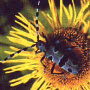
Leafy
fúzač
alpský
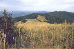
A considerable variety of nature and land of Zemplin has redouned conservators to establish large and small areas of reserves. On this area are four large reserves: National park Poloniny reservation East Carpathian Mountainsn reservation Vihorlat and Latorica. National Park Poloniny The net of national parks was increased by this national park 23. 9. 1997. It is located in north-east part on Slovak-Poland-Ukraine border. The area of national park orographically belongs to East-Carpathian Mountains which begin in this area. This mountain unit is known in Slovakia under the name Bukovské hills. The name gave him unigue mountain meadows extended above forest level - called polonina.
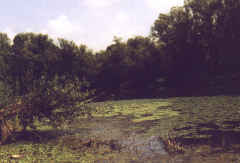
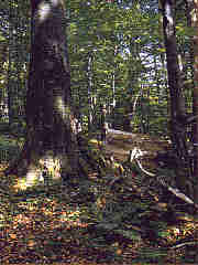
The acreage is 29 805 ha, 80 % are forests. Abnormality of this area resides in appearance of the biggest complex of aborigine beech-fir forests in Europen partly also primeval forests, and in special concentration of meaningful and endangered species of plants and animals. Reservation Latorica Reservation latorica Established 25. 6. 1990. It spreads along river Latorica and flows of Laborec and Ondava in area of 15 620 ha. lt is a second largen plain type reserve. In present it is a unique well-preserved set of meadow forests, dead river branches, of rare and meaningful water and marish biocenize which doesn't have any similarity in whole Slovakia. Reservation Vihorlat
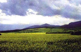
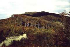
Vihorlat was declared for the reservation 28. 12. 1973. lt spreads in districts Michalovce, Sobrancen Humenné and Snina with acreage of 17 485.24 ha.This area is covered mainly with beech forests. Vihorlat is in spite of its small extent and heigh above sea level an impressive volcanic mountain. lt is on high rope of large East-Slovak lowland and its highest peaks overreach 1 000 meters. lt belongs to the woodiest mountain of Slovakia with predominance of leafy mainly beech forests. lts geographic location and particular geological evolution has conditioned the occurrence of natural strangeness, like Sea eyen Sninský rock, mosses and a common appearance of plant species of West-Carpathian and East-Carpathian flora. In the reservation appear around 35 species of protected plants. The influence of East-Slovak lowland and East-Carpathian Mountains is also seen in animal kingdom of Vihorlat. Here appear 2 000 species of invertebrates and 100 species of birds. Reservation East Carpathian Mountains
Established
1. 9. 1977 with previous area of 96 810 ha. Present reservation
has the acreage of its own territory 26 032 ha, protected zone
was lifted. The reservation copies the border with Poland, it
spreads from south-east to northwest part of Nízke Beskydy.
Here intersects the border of West-Carpathian and East-Carpathian
flora with the appearance of meaningful and endangered species.
For them are specific veldts with heather on acid stands. From species
there are mainly beech and fir forests, in lower areas oaks and
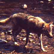
alder meadow forests. Animal kingdom represents otter wolfn lynxn
bear deer and wild animals. |
|
BACK |